Now here’s a tale of clag-enveloped peaks, complex terrain, contact lenses and the absence of reading glasses or lens-on-a-string combining to lead me astray and seek consolation/justification in a statement of the blindingly obvious. Which is quite simply that you’ll go wrong if you can’t see what you need to see (in this case not just the hills but the map and GPS as well)!
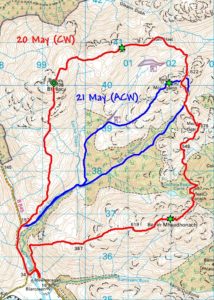
So I was looking for something to run on the way back from Oban because I had a contact lens check there yesterday morning, and settled on the interesting-looking round of three Grahams between Barcaldine and Bonawe. But I was surprised to get away from Specsavers still wearing my contacts when I’d expected to be changing into my glasses there, so hit the hills with contacts but no reading glasses or lens-on-a-string (my typically more practical, optician-suggested alternative). Which basically meant that I couldn’t read map or GPS detail at all, even zooming right in on the GPS. Which proved somewhat problematic because the terrain was complex and the weather flattered to deceive by closing right in after an encouraging (if brief) initial view of all my peaks. So all I could do was cross-reference what I could see of the map to what I could see of the GPS, and you’ll note that my track lurches about in an almost ‘drunk’ manner as I struggled to hold the high ground on long, vague ridges with innumerable bumps and knolls to confuse the issue and the clag limiting my views of same to the very ‘local’. That said, everything I did (including that final descent with great dogleg of a finishing flourish and my unknowing failure to visit the true summit of Beinn Mòlurgainn at all) was logical from what I could see at the time, and I left content to have picked up my three Grahams and Graham Top in such miserable conditions. Until I downloaded my track and looked at it, that is…
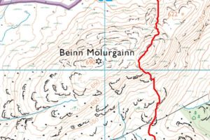
So what happened on Beinn Mòlurgainn? I’d remembered (from the SMC Grahams & Donalds guide) there were two summits, but assumed from what I could see of both hill and map that point 622 was one of them. So came to what I took to be the summit (in truth the lower top), which the map shows to have c.20m prominence (convincing enough if you can’t see the saddle or true summit beyond), looked like a summit, felt like a summit and (confirmed by revisiting today) came complete with cairn. So of course I then started descending towards Meall Dearg, and you can see how it happened if you remember I could see neither true summit nor detail on the map…
Anyway, to cut to the happy ending, I was back today in my (varifocal) glasses to put things right and ran in via a good deer track through the woods above the River Esragan to do just that. While still not getting quite the superb views promised by the SMC book (could see Starav, Trilleachan and Creach Bheinn but still no Cruachan, for which I’ll need to return yet again sometime), I could see enough (including more local hills, map and GPS!) to both collect my missed summit and confirm my previous day’s mistake as understandable. To which I might just add that this is a great wee group of hills that had virtually escaped my radar before. The clockwise round is pretty runnable over Beinn Bhreac and Màm Hael before becoming less free-flowing from the crossing of Beinn Mòlurgainn to summit of Beinn Mheadhonach, where the fine north-east ridge I ascended yesterday proved to be surprisingly steep, well-defined and sportingly scrambly. But how this cracking little peak got its name puzzles me when I’m struggling to see it as the ‘middle’ of anything!
As for contacts vs. glasses, the jury’s still out but tempted to say both suck when glasses can become virtually useless through rain or steaming up and contacts leave me with potentially insoluble reading problems where the reading glasses or lens-on-a-string don’t provide the whole answer and even varifocal contacts probably wouldn’t work for me…


