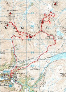
With more miserable weather forecast (MWIS threatening 60mph gusts, persistent rain and lightning although the BBC suddenly/mysteriously changed their guess to ‘sunny’ this morning), today didn’t look like a good bet to check out the Loch Treig hills for my Ramsay’s Round. So Jon came down from the Fort to discuss some detailed routing options for the whole round and then (with things looking ever so much better than expected and us thinking we’d maybe missed a trick by not going for Loch Treig) we set out about midday to see what we could still learn about the Mamores after more hill-running days on that ridge than either of us can remember. And here’s what we sought and found (list numbered to match map below)…
- The best line to bypass Stob Coire a’ Chairn (to avoid going over it twice) on the way from An Gearanach to Na Gruagaichean. Which is something I’ve never got quite right in the past, typically losing the path, contouring too far into the hill (see map from this October 2009 blog post) and popping back onto the ridge too high and too far west. But, in taking the shortcut from point 783 to the bealach before An Garbhanach and back again, we did better today.
- A contouring option to avoid the NW (non-Munro) top of Na Gruagaichean proposed by Yiannis Tridimas in this FRA Forum topic. So normally I’d take the purist approach and go over everything, but the Ramsay’s Round requirements are quite specific in naming the 23 Munros + Sgurr an Iubhair (which has been a Munro) and we had to look at it. On which note we found it easily enough and thought it worthwhile, but I’d say the jury’s still out on this one after getting home and comparing my 2005 Tranter’s split of 50 minutes (taking in said NW top) from An Gearanach to Na Gruagaichean to a combined ‘split’ of 13 minutes from An Gearanach to the bealach mentioned above (15 October 2009) and 36 minutes from there to Na Gruagaichean (today).
- Whether to take the direct route (involving some light scrambling and awkward scree/boulder fields) down the NE ridge (sometimes called NNE ridge?) of Binnein Mor, or…
- The longer but easier (no hands required) alternative by the E ridge (sometimes called NE ridge?), with the direct route emerging as the clear winner [edit, 14 July: not any more… see my comment below and follow-up blog post!] on the assumption that the extra speed required to cover the extra length of the undoubtedly attractive E ridge in the same time is an unlikely proposition.
With today’s stats coming in at 14.52 miles and c.6,500 ft of ascent completed in 4:38:20 (19:09 mile pace), we’ve calculated that (from the more significant ascent figure rather than the mileage) to be about ’21-hour Ramsay’ pace. Which seems fair enough for a shorter training run, but doesn’t (I say again doesn’t) mean I’m predicting that for the big one! To sign off on an upbeat note, however, I’m starting to believe the 24 hours is realistic and I can (should?) do it if my quads hold out (no problems today). And we just beat the rain!


Thinking descending that E ridge of Binnein Mor might yet make sense if we more-or-less followed the line of the watercourse (Allt a’ Gharbh Choire) straight down to pick up the path much nearer the bealach instead of ‘boxing’ that kind of subsidiary lower ridge to the east?
Comment by admin — 11 July 2010 @ 12:15 am
[…] my recent recces with Jon of some suggested ‘shortcuts’ on Na Gruagaichean and the Devil’s Ridge have initially led us in both cases to say ‘that’s worth […]
Pingback by More thoughts about ‘shortcuts’ « Petestack Blog — 14 July 2010 @ 1:04 pm
[…] it was going to be another local run) was to get up into the Mamores again to re-evaluate the options currently under consideration for Na Gruagaichean and Binnein Mor, but I’d hardly been going […]
Pingback by Taking the green line « Petestack Blog — 15 July 2010 @ 10:33 pm