Think yesterday (despite being hot with only intermittent cloud cover) was probably the right choice for a meaty hill run because it’s been absolutely bucketing so far this morning!
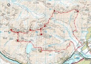
Now, this one was planned as something of a ‘mopping up’ exercise having previously been up Beinn Eunaich but not Beinn a’ Chochuill, and still missing three peripheral tops of Cruachan (Sron an Isean to the east and the ‘Taynuilt peak’ Stob Dearg and Meall Cuanail to the west) that suggested a full traverse as the only tidy way to pick them up. So I hit on the idea of this greater traverse taking in Beinn Eunaich (first time since November 1982!), Beinn a’ Chochuill and the seven tops of Cruachan, with the fine Corbett of Beinn a’ Bhuiridh thrown in as the most aesthetic route back to my starting point on the Stronmilchan road. But that’s a fair way at 19.2 miles with c.10,000 ft of ascent, giving a run that’s shorter on the ground but as strenuous and time-consuming as a serious trail run of twice the mileage. And, if you ask me why I didn’t leave the road for this hefty round until 2:50pm, I can only answer that 1. I was waiting for the post (usually about lunchtime here) in the hope of getting my Nathan Elite 2V Plus (which did indeed arrive) to try, and 2. this is typically me (afternoon and evening runner!) anyway. Which left me finishing minutes before 9:00pm after just over six hours on the hoof for an average speed of 3.1 mph… which might not sound fast at all to the road runner but, as any hill runner can tell you, it’s not mileage but ascent that takes the time. And, with Naismith’s rule suggesting more like 11½ hours for this expedition, I’m really quite satisfied with six (hence the ‘slowly quick’) for terrain where steep ascents and awkward rocky descents are frequently demanding slower speeds yet.
So how about the Elite 2V Plus, and how did that do? Well, the moment I opened the package, I knew that it was quite simply one of the best-designed bits of kit I’ve ever bought. It’s comfortable, stable when running loaded up and just really well thought out with everything (bottles, front pouches etc.) so accessible and clever details like the tuck-back ends to the waist strap. While true (as you’ll see if you go searching for reviews) that some slimmer folk might find the bottles well-placed for elbow-bashing, I must say that I neither run with my elbows glued to my sides nor swing them that much at the kinds of speeds I’m normally doing, so didn’t find this a problem on yesterday’s pretty rigorous testing ground. And the bottles are so accessible in those angled holders that I’d suggest the occasional nudge is a small price to pay so long as it’s not happening all the time. (Might be worth pointing out here that, with 500ml Lucozade Sport bottles dropping easily into the holders made for Nathan’s 650ml bottles, I’m thinking of trying these on the run and keeping the originals for water only. Also that the rear pouch featured on the 2V Plus but not the 2V is most definitely worth having, comfortably takes a large Montane Featherlite Smock in its ‘ball’ and will swallow up the pants as well if both stuffed in loose.) To summarise, while I don’t recall being aware of Nathan before researching bottle belts the other day, I’ve already seen and experienced enough (can’t believe I’ve managed without this for so long!) to believe their kit is amongst the very best for what it does.
And so to a couple of almost random statements to round off…
Firstly, to John Kynaston, no, these hills don’t even bother me. At least, not that much, although the re-ascent to Beinn a’ Bhuiridh was a fair grind on a hot evening! ;-)
And, secondly, to Tracey and friends (on the slim chance that you see this, find it or someone points you here), another belated apology for selfishly abandoning you all to bag Ben Cruachan itself when you’d had enough after Stob Diamh or Drochaid Ghlas in November 2000 (?). I shouldn’t have done that then, and wouldn’t do it now.


Hi Peter, some years ago I walked (no running then) over Beinn Eunaich and Beinn a’ Chochuill, descending down the ridge to Glennoe and then to Taynuilt. It was a beautiful day, blue sky, big views. And I remember having just the best-tasting pint in the pub on the platform at Taynuilt station. (Wonder if it is still there?). I like your route maps, by the way. What do you use to plot them?
Cheers,
Iain
Comment by xiain — 24 May 2010 @ 10:09 am
Dunno about the pub, but the route maps are just .gpx tracks imported into Memory-Map with the stock settings. Made my own custom icons for Munros, Tops, Deletions and Corbetts using outline shapes for unclimbed and coloured for climbed, but doubt you’ll see many of the ‘unclimbed’ ones on maps of where I’ve been!
Comment by admin — 25 May 2010 @ 7:53 am