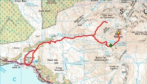
Seduced by a fine forecast on Sunday, I headed for Beinn Resipol above Loch Sunart anticipating (to quote the SMC Corbetts guide) ‘one of the finest views along the West Highland Coastline’. And the hills certainly looked great as I left the house, but things were already changing as I hit the Corran Ferry with my peak subsequently disappearing almost as I left the van to leave a day of clag and intermittent drizzle/snow showers. So I never even saw the mountain properly, let alone the famous views…
Now, you might wonder why I’ve chopped part of my GPS track and I suppose I’d better fess up. Having ascended via the Graham Top of Beinn an Albannaich and stopped to talk to a guy called Ben (who lives in Fife and works as a ranger in West Lothian) atop Resipol, I thought to vary my descent (to ‘make a nicer shape on the map’) by descending the attractive-looking eastern ridge a short way and swinging back round west past the northerly lochan somewhere. But afraid I neither really gave the map more than a cursory glance nor really thought that through, so followed my nose way too far east creating a horrible shape as I contoured and climbed my way back from where I’d never have gone with better visibility! So I’ve, um, ‘censored’ my track round the ‘wrong’ side where it stays between me and the mountain, but am happy to tell you the silver lining of this particular cloud was meeting Ben (who’d lingered some considerable time on the summit hoping things might clear) again just where my ascent and descent tracks converge for a sociable descent with much interesting discussion on the way.


