Short Trail Routes from Kinlochleven
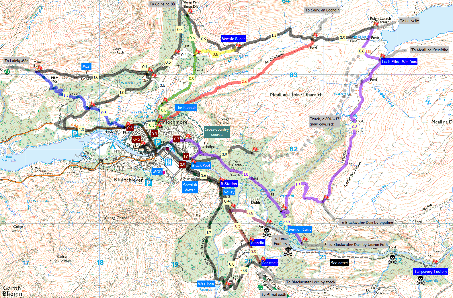
This page (new, May 2016) is a by-product of putting together a map and some notes for short (part-day) training walks for our school DofE Bronze groups, but may be useful/of interest to any runners or walkers wondering where to go? It doesn’t include any longer trail or true hill routes (both outside its envisaged scope), but does cover most of what’s available off-road between about 5 km (3 miles) and 10 km (6 miles), so ranging from half-to-one-hour runs for the speedy to possibly half-day walks for the more leisurely-inclined. All distances and notes assume a start/finish point at the school gates, with the notes being quoted verbatim from what I wrote for the school and best read with that in mind...
[Maps updated December 2016 to show new tracks for Loch Eilde Mòr hydro scheme, and again February 2019 since they’ve mostly been covered over again.]

Map links to larger version (PNG, 597K)

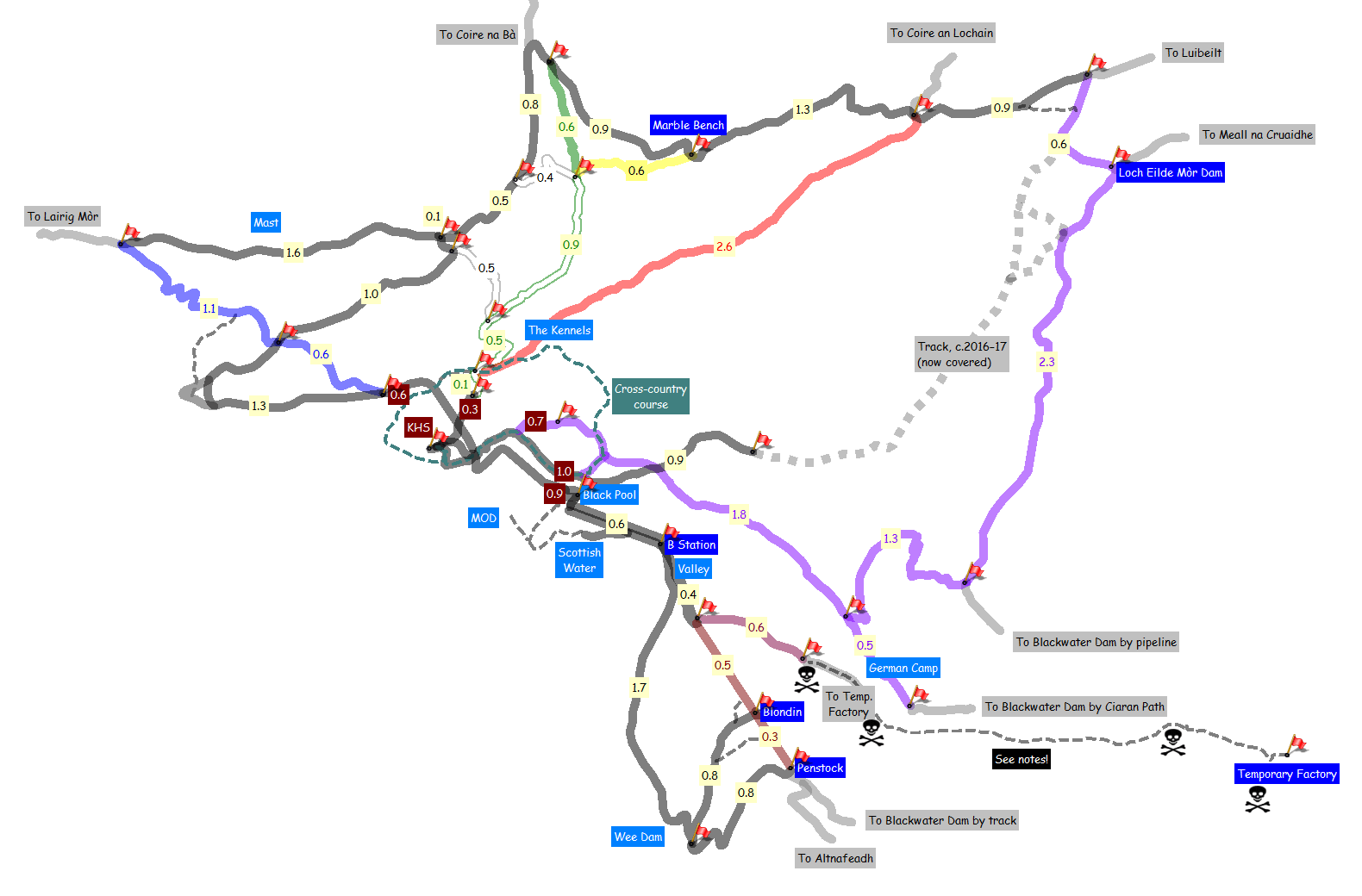
Map links to larger version (PNG, 48K)
Training Walks Map
- All distances are between two marked points (flags), in kilometres, and approximate (rounded to 0.1 km).
- Places labelled with the darker blue (e.g. B Station) match flags exactly but those labelled with the lighter blue (e.g. Valley) may be between flags.
- Most of the flags mark clear path/track junctions, but some don’t (e.g. SE end of the German Camp).
Notes: Main Pipeline to Penstock
- You can take either side of the pipes at the bottom, crossing to/from the main track at B Station.
- There are three 0.4 km options following the pipeline through the ‘Valley’: a track right beside the pipes, a higher track and a narrower path splitting from and rejoining the higher track.
- Following the pipeline uphill from SE end of the valley, you should leave the lower track to briefly swing right onto the higher track to avoid stooping through two concrete tunnels with brambles where the lower track ends!
- The 0.6 km path splitting off from that point towards the river/temporary factory is wet/muddy/boggy and should not be taken beyond the first ford (awkward/dangerous water crossings below the sluices).
- The 0.5 and 0.3 km pipe sections are rough and rocky, but can be taken all the way to the Penstock.
- The ‘Blondin’ is an obvious steel gantry (you can’t miss it when sticking strictly to the pipes!).
Notes: Coloured Trails
- All the colour-coded trails (Blue, White, Green, Yellow, Red) start from the Grey Mare’s carpark, with the first and most obvious start to the Red Trail now signed ‘Kinlochleven Community Trust Loch Eilde Path’.
- The Blue Trail hasn’t been marked on the map because its sole unique section only goes to the base of the falls.
- The White, Green and Yellow Trails share much common ground, only becoming distinct in their upper sections leading to the main track.
- Note that the established route up the first steep (0.5 km) White/Green/Yellow section now breaches the old wall c.15 metres SW of its marker post, but is obvious. Ascending this section, stick to the main path near top of Grey Mare’s and don’t take narrower left fork to top of falls.
- The 0.5 km section of the White Trail (the ‘Ice House’ path) can be awkward in descent when wet.
- The 0.4 km top section of the White Trail tends to be muddy/overgrown at its top (west) end.
- The 0.6 km top section of the Green Trail suffers from encroaching vegetation in summer.
Notes: Ciaran Path and Loch Eilde Mòr Pipeline
- It is 1.8 km along the Ciaran Path from either the Loch Eilde Road or Wade’s Road starts to the junction with the path up to Leitir Bo Fionn, and 0.5 km from there to the far end of the German Camp.
- The Ciaran Path, zigzags to Leitir Bo Fionn and pipeline path to Loch Eilde Mòr are all frequently wet, with the northern end of the pipeline path rarely if ever drying completely. The Ciaran Path also suffers from encroaching bracken in summer.
Some possible routes (NB you can mix and match anything from the map!)
- Ice House loop (c.5.4 km, best anticlockwise)
Up the White Trail to Mamore Lodge, past the mast and down the West Highland Way. Three obvious White/Green/Yellow extension possibilities at 6.6, 7.6 and 8.5 km respectively, the last of which is described below as Marble Bench west loop.
- To the German Camp (c.6.0 km)
A straight out-and-back (not loop) along the Ciaran Path from Loch Eilde Road start.
- Blondin or Penstock loop (c.6.5 km or 6.8 km, best clockwise)
To Black Pool by N of river, then N of pipes to cross at B Station, through the Valley and continue up the pipes. Descend by main track and return by Lab Road (i.e. S of river).
- Marble Bench east loop (c.6.7 km, best clockwise)
Up the Yellow Trail to the Marble Bench, east towards Loch Eilde Mòr and return by An Cumhann/The Kennels (Red Trail).
- Marble Bench west loop (c.8.5 km, best anticlockwise)
Up the Yellow Trail to the Marble Bench, then west by the big hairpin, Mamore Lodge and past the mast to descend by the West Highland Way.
- Loch Eilde Mòr pipeline loop (c.10.3 km, best anticlockwise)
A longer loop taking the Ciaran Path (Loch Eilde Road start), Leitir Bo Fionn zigzags and Loch Eilde Mòr pipeline to return by An Cumhann/The Kennels (Red Trail). Distance was measured for the old path at the north-east corner (now shown dashed) and will be marginally further by the new track.
Note: the old Temporary Factory is an interesting site to visit but simply not appropriate to a Bronze training walk. For those who must know, the safest route is to take the Ciaran Path to the chimney stack opposite and cross the River Leven direct to the site, which is not difficult when the river’s low but should only be attempted in such conditions.
Feedback to webmaster@petestack.com
Valid HTML5